


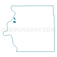
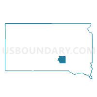
VTD-Chamberlain district 3, Brule County, South Dakota
About
Outline

Summary
| Unique Area Identifier | 667063 |
| Name | VTD-Chamberlain district 3 |
| County | Brule County |
| State | South Dakota |
| Area (square miles) | 1.89 |
| Land Area (square miles) | 1.88 |
| Water Area (square miles) | 0.01 |
| % of Land Area | 99.31 |
| % of Water Area | 0.69 |
| Latitude of the Internal Point | 43.78116140 |
| Longtitude of the Internal Point | -99.30881650 |
Maps

Graphs
Select a template below for downloading or customizing gragh for VTD-Chamberlain district 3, Brule County, South Dakota


Neighbors
Neighoring Voting District (by Name) Neighboring Voting District on the Map
- VTD precinct 1, Brule County, SD
- VTD-Chamberlain district 2, Brule County, SD
- VTD-Chamberlain district 4, Brule County, SD
Top 10 Neighboring County Subdivision (by Population) Neighboring County Subdivision on the Map
- Chamberlain city, Brule County, SD (2,387)
- Chamberlain township, Brule County, SD (191)
- Pukwana township, Brule County, SD (145)